1. Publications
Scopus:
1. Hybrid feature-based neural network regression method for load profiles forecasting
This study addresses the urgent need for improved demand forecasting models that can accurately predict energy consumption, especially under different geographical and climatic conditions. A novel demand forecasting model is proposed that combines clustering and feature engineering techniques with neural network regression, with a special focus on accounting for correlation with air temperature. The performance of the model is evaluated using a benchmark dataset from Tetouan, Morocco, where existing forecasting methods exhibit RMSE values ranging from 6,429 to 10,220 [MWh]. In contrast, the proposed model achieves a significantly lower RMSE value of 5,168, demonstrating its superiority. A subsequent application of the model to demand forecasting in Astana, Kazakhstan, as a case study further validates its performance. A comparative analysis with the baseline neural network showed a significant improvement: the proposed model achieved a MAPE value of 5.19%, while the baseline model achieved 17.36%. These results highlight the potential of the proposed approach to improve the accuracy of demand forecasting, especially in diverse geographical contexts, by using climate factors. The methodology also shows promise for broader applications such as flood forecasting, crop yield estimation, and water management.
Satan A. et al. Hybrid feature-based neural network regression method for load profiles forecasting //Energy Informatics. – 2025. – Т. 8. – №. 1. – С. 19. https://doi.org/10.1186/s42162-025-00481-0
2. Spatiotemporal Analysis of Soil Moisture Variability and Precipitation Response Across Soil Texture Classes in East Kazakhstan
The study of the hydrological regimes of rivers in different regions of the globe has revealed the need to include the soil moisture content in flood prediction models. This paper investigates the nature of the dependence of soil moisture content on soil texture in the East Kazakhstan region. Data from ERA-5-land reanalysis, soil maps, hydrogeological maps, and the meteorological data of Kazhydromet were used. The years for analysis were selected due to their different moisture conditions. This study analyzed soil moisture within the root zone (0–28 cm depth). A JavaScript-based algorithm was developed in Google Earth Engine to analyze soil moisture and total precipitation across five Soil Texture Index categories during the growing seasons (April–September) of 2013, 2022, and 2023. Final cartographic processing and spatial distribution analysis were conducted using ESRI ArcGIS Pro 3.3. The study of soil moisture’s relationship with different soil textures in the East Kazakhstan region has revealed several key trends. The maximum values of soil moisture for each texture class change very slightly from year to year. The minimum soil moisture values fluctuate more strongly from year to year. The regression analysis demonstrates a statistically significant relationship between precipitation and soil moisture. The best performance is achieved when using a 1-day lag for 2013 and varying optimal lags for 2022 and 2023 (ranging from 1 to 3 days) during the high-precipitation period (months 6–9), with filtering applied to remove days with negligible rainfall.
Chernykh, D., Biryukov, R., Bondarovich, A., Lubenets, L., Pavlenko, A., Rakhymbek, K., Revenko, D., & Zhantassova, Z. (2025). Spatiotemporal Analysis of Soil Moisture Variability and Precipitation Response Across Soil Texture Classes in East Kazakhstan. Land, 14(6), 1136. https://doi.org/10.3390/land14061136
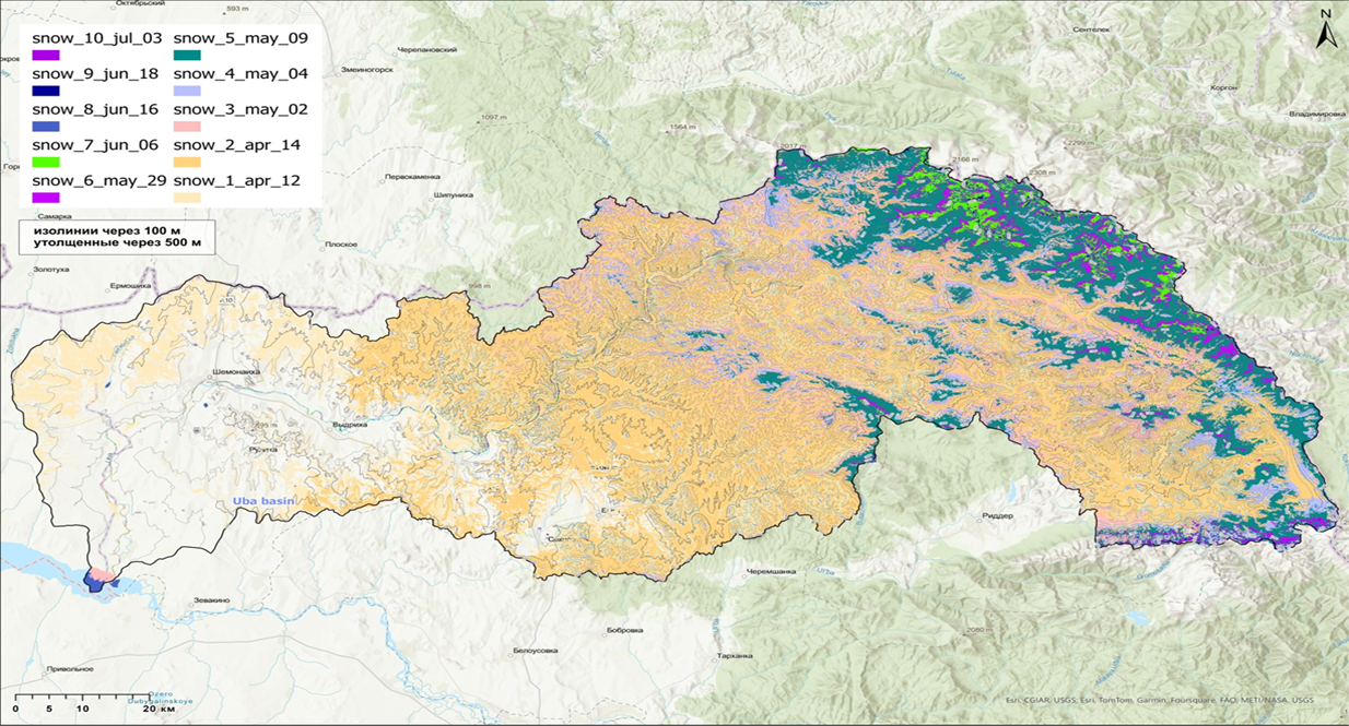
3. Assessment of Maximum Snow-Water Equivalent in the Uba River Basin (Altai) Using the Temperature-Based Melt-Index Method
The assessment of the maximum snow-water equivalent in mountains is important for understanding the mechanism of their formation, as well as for hydrological calculations. The low density of the observation network and the high complexity of ground-based snow-measuring operations have led to the widespread use of remote methods to obtain such data. In this study, the maximum water reserve of the Uba River basin was calculated for the period of 2020–2023, based on data from the Sentinel-2 satellite regarding the position of the seasonal snow line, obtained using the temperature-based melt-index method. This study determined the snowmelt coefficients for the meteorological stations at Zmeinogorsk, Shemonaikha, and Ridder. Maps were constructed to show the distribution of the maximum snow-water equivalent in the Uba River basin. The spatial differentiation features of the snow cover were revealed, depending on the elevation, slope exposure, and distance from the watersheds. It was established that the altitudinal distribution of snow cover on the northern and southern macro-slopes of the ridges is asymmetric: in the western part of the basin, within the elevation range of 500–1200 m, the maximum water reserves of snow cover are greater on the southern slopes, but they become higher on the northern slopes above 1200 m. In the eastern part of the basin, they are always larger on the northern slopes. The greatest differences in the distribution of snow cover between the slopes occur near the watersheds.
Bykov, N. I., Birjukov, R. Y., Bondarovich, A. A., Zhakiyev, N. K., & Djukarev, A. D. (2025). Assessment of Maximum Snow-Water Equivalent in the Uba River Basin (Altai) Using the
Temperature-Based Melt-Index Method. Climate, 13(6), 117. https://doi.org/10.3390/cli13060117
4. The Calculation and Mapping of the Moisture Indices of the East Kazakhstan Region for the Preventive Assessment of the Climate–Hydrological Background
The assessment of the hydrological functions of landscapes and the landscape–hydrological background is an important instrument for minimizing damage from rivers and preventing water conflicts under conditions of data scarcity for hydrological modeling. To assess the climate–hydrological background of the East Kazakhstan region, the Selyaninov Hydro-thermal Coefficient and the Vysotsky–Ivanov Moisture Coefficient were used. The East Kazakhstan region is a typical continental arid and semi-arid region. The presence of mountain ranges, such as the Altai, makes the climate and environment in the region highly varied. A dataset from 30 weather stations for the period 1961–2023 was used for calculations. Three interpolation methods and landscape extrapolation were used to construct maps of the coefficients. Over the observation period, the values of the moisture indices at the weather stations in the region fluctuated within a wide range. Both coefficients are in the range from extra arid to extra humid climates.
Chernykh, D., Rakhymbek, K., Biryukov, R., Bondarovich, A., Lubenets, L., & Baiburin, Y. (2025). The Calculation and Mapping of the Moisture Indices of the East Kazakhstan Region for the Preventive Assessment of the Climate–Hydrological Background. Climate, 13(7), 142. https://doi.org/10.3390/cli13070142
KOKNVO:
1. Flood Risk Mapping in The Irtysh River Basin Using Satellite Data
Floods are among the most frequent and devastating natural disasters, causing significant economic losses and loss of life worldwide. Effective flood risk management depends on accurate modeling methods that can predict vulnerable areas and assess potential impacts. This study simulates flood dynamics in the Irtysh River basin near the city of Ust-Kamenogorsk (Eastern Kazakhstan), which is prone to seasonal flooding, using high-resolution satellite imagery and digital elevation models. The main objective of the work is to visually model flood risks based on terrain characteristics. The study uses satellite imagery provided by the Map box platform, which combines MODIS, Landsat 7, Maxar and Google Earth Engine data, providing access to Sentinel-2 imagery with surface reflectivity at 10-meter resolution. Elevation data from the Copernicus global digital elevation model with a resolution of 30 meters is used for flood modeling. Flood modelling involves calculating the flood depth relative to the terrain height, allowing each pixel to determine whether it will be submerged. The modelling scenarios assume a stepwise increase in water level to generate a sequence of images that show the dynamics of flooding over time. The study also considers soil hydraulic properties and focuses on visualizing flood risks based on terrain and water level changes. The modelling results show that the riverbanks are primarily affected by flooding, with water flows spreading from the north-west of the city. Critical infrastructure becomes vulnerable when the water level exceeds 2 meters from the lowest point of the terrain. These results highlight the potential of using high-resolution satellite imagery and terrain data to assess flood risks and improve urban flood preparedness. The data obtained provided valuable insights into flood development, facilitating more informed decision-making to reduce the impact of natural disasters.
Rakhymbek K., Zhomartkan N., Nurekenov D., Zhantassova Z. Flood Risk Mapping in The Irtysh River Basin Using Satellite Data //Scientific Journal of Astana IT University. – 2024. – Т. 19. – С. 140-149. https://doi.org/10.37943/19LRYW4856.
2. High-Resolution Satellite Estimation of Snow Cover for Flood Analysis in East Kazakhstan Region
The increasing frequency of extreme weather events associated with climate change makes flood forecasting particularly relevant, particularly for mountainous regions where snowmelt is the main driver of seasonal flooding. This study examines the application of snow cover assessment methods to analyze snowmelt dynamics and its potential impact on flood risks in the Ulba and Uba River basins in East Kazakhstan. To achieve this goal, high-resolution multispectral satellite imagery from the Sentinel-2 Surface Reflectance dataset is used. The analysis covers images collected from March to October for 2021–2024. Data processing is performed in the Google Earth Engine platform using strict filtering based on spatial overlap with the studied basins and the proportion of cloud pixels, which ensures high-quality data for snow cover analysis. The study applies several remote sensing indices to estimate snow cover. The Normalized Differential Snow Index (NDSI) is calculated using the green and shortwave infrared bands to identify pixels covered by snow. The fractional snow-covered area (FSCA) is calculated from the NDSI using the empirical equation ‘FRA6T’, which provides a more detailed representation of the distribution of snow across catchments. In addition, a threshold value for the ratio of near-infrared to shortwave infrared is applied, which minimizes the confusion between snow and water, especially near water bodies and during periods of active melt. The resulting snow cover maps and FSCA values provide a detailed representation of snow distribution and melt dynamics, facilitating the assessment of the role of snow runoff in flood risk development. The findings can be used to refine flood forecasting models, improve early warning systems, and support informed water management in vulnerable regions.
Alzhanov A., Nugumanova A. High-Resolution Satellite Estimation of Snow Cover for Flood Analysis in East Kazakhstan Region //Scientific Journal of Astana IT University. – 2024. – Т. 19. – С. 118-127. https://doi.org/10.37943/19VUAO6399.
3. Interrelationships between snowpack dynamics and tree growth in the Tigiretsky Ridge (Altai): Implications for ecological responses to climate variability
This study examines the complex interaction between snow cover dynamics and tree growth in the Tigiretsky Range using dendrochronological and snow cover data from 2013 to 2020. Using the Temperature-Based Melt-Index Method, the maximum snow water equivalent during winter months was accurately estimated, revealing significant spatial variability due to elevation, slope aspect, and proximity to watersheds. The results indicate an asymmetric distribution of snow cover, with southern slopes at low elevations having higher snow reserves, while this situation is reversed at higher elevations. Notably, snow reserves on northern slopes near watersheds can exceed those on southern slopes by up to 30 times. The analysis also revealed a positive correlation between the increase in snow water equivalent and the radial growth of Abies sibirica L. (Siberian fir) in the treeline ecotone, indicating a significant ecological response of trees to changing snow conditions. The findings contribute to a deeper understanding of the impact of climate variability on snow-vegetation interactions in mountain ecosystems, forming the basis for further research aimed at uncovering the mechanisms of these relationships.
Bykov N. I., Birjukov R. J. Interrelationships between snowpack dynamics and tree growth in the Tigiretsky Ridge (Altai): Implications for ecological responses to climate variability // Acta Biologica Sibirica. – 2024. –V. 10. – P. 1319–1336. https://doi.org/10.5281/zenodo.14190443 (The journal is indexed in Scopus in the direction Environmental Science -> Ecology; Global and Planetary Change, journal percentile – 29).
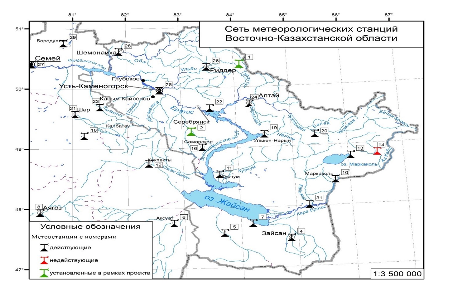
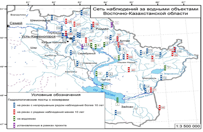
4. Monitoring system and provision of flood forecast data in the East Kazakhstan region
This article is devoted to the collection of available information on water bodies in the East Kazakhstan region, obtained from open sources – data provided by the Republican Hydrometeorological Service and the Ministry of Emergency Situations of the Republic of Kazakhstan. The purpose of the work is to create a spatially referenced attribute database within the GIS platform, as well as to form the basis for further research aimed at developing and implementing flood forecasting models. A review of existing studies in the field of flood forecasting was conducted both in the regions of Kazakhstan and abroad, which made it possible to formulate criteria for assessing data and hydrological monitoring systems. The article also provides a description of the hydrological regime of key representative water bodies in East Kazakhstan. Based on the spatial analysis of the network of hydrological stations and known flood zones, an assessment of the spatial coverage of the state observation system was carried out, based on the results of which recommendations were developed for its expansion. In conclusion, conclusions were made on the applicability of the collected data for building predictive models.
Pavlenko A.V., Mansurova A.K., Kyzyrkanov A., Chernykh D.V. Monitoring system and provision of flood forecast data in the East Kazakhstan region // Bulletin of the Karaganda University. Series Biology. Medicine. Geography. – 2024. – T. 4. https://doi.org/10.31489/2024bmg4/183-196
5. Feature selection methods for lstm-based river water level and discharge forecasting
Accurate forecasting of river flow and water levels is critical for effective water resources management, flood mitigation, and public safety. This study compares correlation analysis and PCA-based feature selection methods for LSTM-based forecasting models in the Uba River basin, Shemonaikha city, East Kazakhstan region. The original dataset covers the period from 1995 to 2021, with 1995–2019 data used for training and validation of the models and 2020–2021 data for testing. Both feature selection methods reduced the original set of predictors to 13 variables while maintaining overall forecast accuracy. To improve the stability of predictions and reduce variance associated with random initialization, an ensemble model of 10 LSTM networks was trained using 60-day-long input sequences and forecasting for a 10-day horizon. Model performance was assessed using the Nash–Sutcliffe Efficiency (NSE) metric. The results showed that the correlation-based feature selection method provided comparable accuracy to the model using the full feature set when tested on 2020 data, suggesting that excluding highly correlated features does not reduce the model’s short-term forecasting ability. The model with PCA-based features demonstrated some lag at longer horizons in 2020 but showed an advantage at most horizons in 2021. However, the overall forecast accuracy in 2021 decreased compared to 2020, reflecting greater variability in hydrological conditions and their deviation from historical training data, indicating the need for periodic model updates with new data. Both feature selection methods effectively reduced the data dimensionality while maintaining the predictive ability of the models. However, neither method was universally superior across all forecast time horizons. These results highlight the importance of a systematic approach to feature selection in hydrological models and the need to adapt models to changing environmental conditions.
Alzhanov A., Nugumanova A. FEATURE SELECTION METHODS FOR LSTM-BASED RIVER WATER LEVEL AND DISCHARGE FORECASTING //Scientific Journal of Astana IT University. – 2025. – Т. 21. https://doi.org/10.37943/21EHLH9882
6. Development of methodology for GIS assignments in flood mapping using Bloom’s taxonomy and scaffolding approach
This paper presents a study on designing and implementing a series of GIS assignments for an educational course on flood mapping, structured using Bloom’s Taxonomy and the scaffolding teaching method. Geographic Information Systems (GIS) education often involves the acquisition of complex technical skills, requiring a structured learning approach to ensure a progressive mastery of concepts. In this study, a sequence of practical assignments was developed at increasing levels of complexity corresponding to Bloom’s cognitive levels, from basic knowledge acquisition to higher-order evaluation tasks. The scaffolding approach was utilized to facilitate student learning, wherein extensive guidance was provided in early tasks and gradually removed in later ones as students gained competence. The research was conducted in an upper-level undergraduate course, “Methodology for Mapping Flood Emergency Areas”, at the Sarsen Amanzholov East Kazakhstan University, with 21 enrolled students. The assignments integrated real-world flood mapping scenarios using GIS tools such as ArcGIS Pro and QGIS, enabling students to apply theoretical knowledge in practical settings. Results from the study indicated that a structured, scaffolded approach significantly improved student performance and confidence in GIS skills. Quantitative analysis of assignment grades showed steady improvement as students progressed to more complex tasks, while qualitative feedback revealed high engagement and perceived learning value. The findings underscore the effectiveness of combining Bloom’s Taxonomy with scaffolded
instruction in GIS education, providing a practical framework for curriculum design. This approach has the potential to enhance learning outcomes in technical subjects, particularly in geospatial analysis, and offers recommendations for educators on implementing scaffolded assignments effectively. Further research could explore long-term skill retention and the application of this methodology in other technical disciplines.
Pavlenko, A., Makhambetova, Z., Chursin, A., Kyzyrkanov, A., & Tleshova, Z. (2025). DEVELOPMENT OF METHODOLOGY FOR GIS ASSIGNMENTS IN FLOOD MAPPING USING BLOOM’S TAXONOMY AND SCAFFOLDING APPROACH . Scientific Journal of Astana IT University, 21, 196–215. https://doi.org/10.37943/21ZZUB3172
2. Direct results
– A set of long-term data on precipitation, snow reserves, temperature conditions and solar radiation, water bodies and a set of satellite images of catchment areas and flood zones in the East Kazakhstan region have been collected.
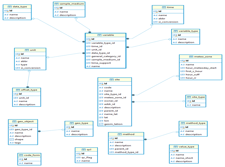
– – Digital elevation models of catchment areas and flood zones and a conceptual model of a geo-relational database of water resources in the East Kazakhstan region have been developed.
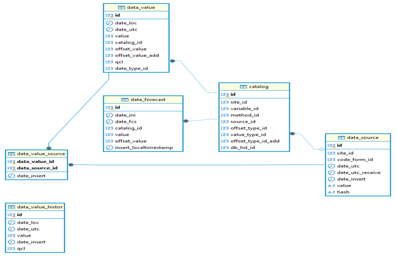
– – A conceptual model of a geo-relational database of water resources in the East Kazakhstan region has been developed based on the ODM (Observation Data Model). PostgreSQL DBMS with the PostGIS extension, which provides support for geodata and geospatial analysis, was used for implementation.
– – 2 hydroelectric stations and 2 meteorological stations have been installed in the East Kazakhstan region.
Place of program implementation:
1. Astana – Astana IT University.
2. East Kazakhstan region, Ust-Kamenogorsk – East Kazakhstan University named after Sarsen Amanzholov.